Showing posts with label Earthquake. Show all posts

A magnitude 4.2 earthquake struck near Grand Coulee Dam, the largest U.S. hydropower facility, in northeastern Washington state on Tuesday, prompting an immediate inspection of the facility but leaving no visible damage, a spokeswoman said.
Operation of the Columbia River dam, which supplies electricity to 11 Western states, was not disrupted by the tremor, according to the spokeswoman, Lynne Brougher of the U.S. Bureau of Reclamation, the agency that runs the dam.
The U.S. Geological Survey reported the quake was centered about 25 miles (40 km) north of the dam near the town of Nespelem in heart of the sprawling Coleville Indian Reservation, an area ravaged by a major wildfire in recent days.
Weak to light shaking was felt over a wide region, but there were no immediate reports of damage of injuries. Earthquakes of that magnitude are not uncommon in seismically active Washington state, but Tuesday's 4.2 tremor was the first to strike this close to the dam "in quite a while," Brougher said. "Oh, it got our attention. Everybody felt it," she said, adding that the trembling went on for roughly 30 seconds. She said it would take several hours for dam officials to complete their inspection of the mammoth facility. Grand Coulee stands 5-1/2 stories tall, is 500 feet (152 meters) thick at its base, and stretches nearly a mile (1.6 km)across the Columbia River to form Lake Roosevelt, which provides drinking water and irrigation supplies for communities and farms in the region. The dam includes three major hydroelectric power-generating plants and a pump-generating plant that average a combined 21 billion kilowatt hours of electrical output a year. It also controls stream flow for flood management, fish migration and recreation downstream.
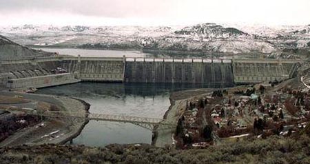
The original dam structure was completed in 1941, with additions made in the 1960s and '70s. Source

The USGS reports that a 3.5 magnitude earthquake hit 16 miles northwest of Covington, TN at 8:26 a.m. People near Memphis, Tenn. felt an natural disaster Tuesday morning, according to WREG, a CBS affiliate. The quake was shallow.

WREG-TV reports no damage in the area.

The New Madrid fault line is about twenty times larger than California’s famed San Andreas fault. The biggest earthquake in U.S. history happened in the New Madrid seismic zone in 1812.  The fault line has been more active over the last few years.
An natural disaster centered in eastern Arkansas rattled residents in multiple states in late October, making the quake the largest in the NMSZ in several years. Small earthquakes happen from time to time along the area. “Prehistoric earthquakes similar in size to those of 1811-1812 occurred in the middle 1400’s and around 900 A.D”. Officials told news “It is one of the most active natural disaster areas in the Southeast”.
University of Memphis natural disaster Center’s Gary Patterson also said he did not think an quake of this magnitude would likely cause much damage.

Source: fox2now.com & dispatchtimes.com


A 5.2-magnitude earthquake occurred Sunday off the coast of the Republic of El Salvador, the United States Geological Survey (USGS) reported. The quake was recorded at 2015-08-23 04:48:49 (UTC on Sunday) at a depth of 49.3 kilometers (30.6 miles)
The epicenter of the quake was located (according to USGS):
  • 67km (42mi) SW of Acajutla, El Salvador
  • 85km (53mi) SW of Sonsonate, El Salvador
  • 87km (54mi) SW of Sonzacate, El Salvador
  • 91km (57mi) SW of Izalco, El Salvador
  • 129km (80mi) WSW of San Salvador, El Salvador

So far the authorities have reported no injuries shake people; or damage in areas where the quake was felt. The town of Alegria in Usulutan (east of El Salvador) was hit last week by an earthquake that left two children under age wounded, 69 homes with major damage and 23 with minor injuries.
In El Salvador, which is part of the so-called Pacific Ring of Fire, earthquakes are frequent due to the intense seismic activity.

Source: sputniknews.com, lainfo.es and earthquake.usgs.gov


Magnitude 4.2 Earthquake Hits Trinidad near Colorado. According to United States Geological Survey the exact time of this earthquake happens 05:14:09 (UTC)
This earthquake occurred the place from 38 KM (24mi) W of Trinidad, Colorado. The Exact location of this Quake exposes USGS and its 37.106°N 104.928°W depth=5.0 km (3.1 mi). 

The earthquake place nearby cities are Pueblo,  Pueblo West, Canon City from Colorado and NNE of Santa Fe, New Mexico. And the distance from this quake also revealed USGS:

  1. 38km (24mi) W of Trinidad, Colorado
  2. 130km (81mi) SSW of Pueblo, Colorado
  3. 139km (86mi) S of Pueblo West, Colorado
  4. 150km (93mi) S of Canon City, Colorado
  5. 181km (112mi) NNE of Santa Fe, New Mexico


Be safe where you are………….

According to the U.S Geological Survey A Magnitude 4.0 Earthquake Hits San Francisco Monday morning in Piedmont, California near Oakland.

The exact time of happening this quake at 6.49 a.m pacific time at depth of 3.1 miles.

The USGS also reported the Epicenter was two miles from Emeryville, California, 3 miles form oakland, 3 miles from Berkelay and 64 miles from Sacramento.  The Quake was felt most strongly on the East Bey, including Oakland, Berkeley and surrounding areas. Leaser shaking was felt in San Francisco.

Once I was writing this article there were no damage or injury reports.

"Although many calls continue, no reports of damage or injury in#Oakland," Oakland police Lt. Chris Bolton said on Twitter.
Residents said the quake lasted only a few seconds and sounded like a tree limb cracking. The quake was centered near the junction of the 24 and 13 freeways. Six aftershocks followed.
The temblor appears to have occurred along the Hayward fault, which experts have long said could produce a devastating quake. The fault runs below heavily populated areas of the East Bay. The fault has produced some small quakes recently, including a 4.0 in Fremont in July.
Studies have estimated that a massive quake on the fault could cause $32 billion and leave 20,000 dead and injured.
The Hayward fault, a major branch of the San Andreas fault system, runs for more than 60 miles from Fremont through Hayward, and from goal post to goal post underneath UC Berkeley's football stadium. It runs underneath freeways and aqueducts and close to Bay Area reservoirs, freeways and hospitals.
Geologists divide the fault into two portions: a northern stretch that runs from the Oakland and Berkeley border past El Cerrito, and a southern stretch running from Oakland to Fremont.
Historical records show that the southern portion of the fault ruptured in 1868, in a quake that was known as "the big one" until the 1906 San Francisco quake. It was long thought that the northern part of the fault had ruptured in a large 1836 earthquake.
This information comes from the USGS Earthquake Notification Service.
Source:- latimes.com & http://earthquake.usgs.gov/

Recently Magnitude 6.6 EarthQuake hits Solomon Islands. And Its a major quake than previous. The Magnitude happens 214km W of Lata, Solomon Islands away. In few minutes ago USGS reported there website the 'Preliminary Earthquake Report'

Preliminary Earthquake Report
Magnitude    6.6
Date-Time
  • 15 Aug 2015 07:47:06 UTC
  • 15 Aug 2015 18:47:07 near epicenter
  • 15 Aug 2015 01:47:06 standard time in your timezone
Location10.905S 163.877E
Depth6 km
Distances
  • 214 km (132 mi) W of Lata, Solomon Islands
  • 460 km (285 mi) ESE of Honiara, Solomon Islands
  • 623 km (386 mi) NW of Luganville, Vanuatu
  • 894 km (554 mi) NNW of Port-Vila, Vanuatu
  • 1054 km (653 mi) ESE of Arawa, Papua New Guinea
Location UncertaintyHorizontal: 7.7 km; Vertical 4.2 km
ParametersNph = 104; Dmin = 459.9 km; Rmss = 1.04 seconds; Gp = 22°
Version =
Event IDus 100032k6

A minor earthquake magnitude 3.3 has occurred on Friday, 63km ESE of Lakeview, Oregon. This minor earthquake's exact location 41.916°N 119.621°W depth=9.2 km (5.7 mi). USGS reported its nearby cities information: 
  1. 67km (42mi) ESE of Lakeview, Oregon
  2. 178km (111mi) E of Altamont, Oregon
  3. 182km (113mi) E of Klamath Falls, Oregon
  4. 187km (116mi) NNE of Susanville, California
  5. 305km (190mi) N of Carson City, Nevada
Date and time of earthquake in UTC/GMT: 15/08/15 / 2015-08-15 03:43:34 / August 15, 2015 @ 3:43 am. The epicenter was at a depth of 5 km (3 miles). Id of earthquake: us100032jc. Event ids that are associated: us100032jc, uw61067286.
Each year there are an estimated 130,000 minor earthquakes in the world. Earthquakes 2.5 to 3.5 are often felt, but only causes minor damage. In the past 24 hours, there have been two, in the last 10 days seven, in the past 30 days twenty-eight and in the last 365 days three hundred and four earthquakes of magnitude 3.0 or greater that has struck near.

DID YOU FEEL THE QUAKE?

What was your situation during the earthquake? Leave a comment or report about damage, shaking and activity at your home, city and country. This data comes from the USGS Earthquake Notification Service. Read more about the earthquake, Seismometer information, Distances, Parameters, Date-Time, Location and details about this quake, that has occurred near: 63 km ESE of Lakeview, Oregon.